Remote sensing technology-based estimation of atmospheric CO2 concentration to support efforts to reduce greenhouse gas emissions.
Tóm tắt
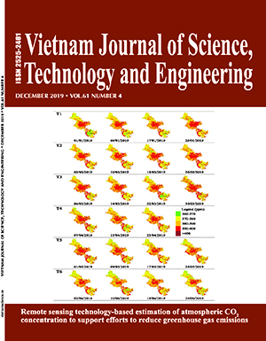
Due to the strong development of agricultural and industrial activities in this day and age, the widespread use of fossil fuels has caused the concentration of greenhouse gases in the atmosphere to significantly increase. With a high concentration of greenhouse gases comes an increase in the temperature of the Earth, which contributes to the acceleration of climate change. This paper presents a remote sensing technique capable of determining atmospheric CO2 concentrations from spectral radiation values obtained by satellite images, thereby simulating the distribution of CO2 concentrations over the entire city of Ho Chi Minh. This study uses two data sources: greenhouse Gases Observing Satellite (GOSAT) and Moderate Resolution Imaging Spectroradiometer (MODIS) images. Calculation results show that throughout the city the average CO2 concentration in the first 6 months of 2019 has a minimum value of 360 ppm and maximum value of 410 ppm; these values change monthly and depend on the type of surface land cover. The highest concentration of CO2 is found over areas of water, bare land, and urban land. On the contrary, over green areas and forests, the CO2 concentration values are about 360-370 ppm. These results are a suitable reference available to support strategic planners focused on CO2 emission management, and suggest that expanding urban vegetation to increase the absorption capacity of carbon will contribute to the reduction of the greenhouse effect.Keywords: CO2, GOSAT, greenhouse effect, MODIS.
Classification number: 5.2